GEOGRAPHICAL MAP TAKEN FROM AN ENGLISH OFFICER ON THE BATTLEFIELD OF WATERLOO AND GEMBLOUX, 1815. 18906-33
Sold out
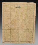
GEOGRAPHICAL MAP TAKEN FROM AN ENGLISH OFFICER ON THE FIELD OF WATERLOO AND GEMBLOUX, 1815. 18906-33
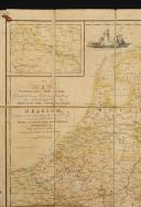
"TRAVELLING MAP OF THE COUNTRIES BETWEEN PARIS AND HAMBURG containing holland, the Netherlands, and the whole of BELGIUM, accurately delineating the direct cross communications between PARIS, STRASBURGH, AMSTERDAM, HAMBURG, &c. with every Post station Published by Samuel Leigh, 18 Strand.
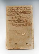
The map is mounted on canvas and cut into 12 sections for folding. When folded, the map has the following handwritten annotation on the canvas:
"Geographical map taken from an English officer on the terrain of Waterloo and Gembloux along with his horse ... (?) ... (?) a deadly sword blow.
1815.
81st Regiment: Fournier
Assistant guard storekeeper of the equipment of the 14th army corps and guard storekeeper of the 4th corps appointed by Mr. Bret, an ordained officer."
The geographical area is delimited by a double line, dimensions within this boundary H 51.5 cm x 41 cm. Exterior dimensions of the map approximately H 55.5 cm x 45 cm.
The canvas support is in very poor condition, with stains, foxing, holes with losses, and rust stains. The map is in fairly good condition, with foxing and water stains, tears, and holes on the edges. No losses in the geographical area.
Reference :
18906-33

Next update Friday, april 4th at 1:30 PM
FOR ALL PURCHASES, PAYMENT IN MULTIPLE CHECKS POSSIBLE
bertrand.malvaux@wanadoo.fr 06 07 75 74 63
An authenticity certificate of the item including the description published on the site, the period, the sale price, accompanied by one or more color photographs is automatically provided for any item priced over 130 euros. Below this price, each certificate is charged 5 euros.
Only items sold by me are subject to an authenticity certificate, I do not provide any expert reports for items sold by third parties (colleagues or collectors).


